This is an updated reprint of a “From the Local History Room” column that first appeared in June 2013 before the launch of this weblog.
In the lore handed down from the days of the pioneer settlers of Tazewell County is a curious tale of a tract of land that came to be known by the colorful name of “the Lost Forty.”
A “forty” is land surveyor’s term that refers to 40 acres of land. Under the Public Land Survey System, the location and boundaries of a tract of land is identified by state, county, township, range, section and section portion. A “forty” is a quarter-quarter section. In 1832, when large areas of Illinois were opened to white settlers, a forty was the smallest tract of land that could be acquired.
How, then, did Tazewell County “lose” one of its forties? The story is told in Ben C. Allensworth’s 1905 “History of Tazewell County,” page 893.
“There is a tract of land in Tazewell County, lying along the Mackinaw River, which consists of a continuous series of abrupt and deep ravines. Not a foot of the tract could be cultivated. The ridges are full of fox dens, wolves are occasionally found, and turkey-buzzards hover over it in large flocks. Even people familiar with the territory have been lost in the dense forest. Except for a few giant oaks the wood has no commercial value.
“The tract is known as the ‘Lost Forty,’ because no one knows who owns it. For years it has been used for trading purposes, and many unwary persons from a distance have advanced money upon it and taken mortgages in various sums, only to receive a questionable title to a worthless piece of land. On the Tazewell County tax-books the ‘Forty’ appears with the ‘owner unknown.’ The land is watered by innumerable springs and the Mackinaw River, which winds its way through the tract.”
This brief account had previously been published in local newspapers, and, as was common newspaper practice in those days, ended up being republished in papers far and wide as “filler,” including the Gloversville, N.Y., Daily Leader in 1903, the Minneapolis Journal of June 7, 1902, the Oregonian of Portland of Nov. 11, 1901, Uhrichsville, Ohio, News Democrat of Dec. 24, 1901, the Bedford, Pa., Gazette of Dec. 27, 1901, and the Anadarko, Okla., Daily Democrat of Dec. 23, 1901.
For some reason, Allensworth did not trouble himself to specify where the Lost Forty was located, but the Anadarko Daily Democrat’s version (which was itself reprinted from the Springfield, Ill., State Journal) expands a little on Allensworth’s words, introducing the tale of the Lost Forty with these words:
“An African jungle transplanted to Central Illinois would be the best description that could be given to a remarkable tract of land in Tazewell county, lying along the Mackinaw river, near the village of Lilly. . . .”
Lilly is located about 3 miles east of Mackinaw, in Sections 14 and 13 of Mackinaw Township. But there is a serious problem with the words, “lying along the Mackinaw river, near the village of Lilly” – the Mackinaw River wends its way through Mackinaw Township a few miles to the north and northwest of Lilly, not really very “near the village of Lilly” at all.
Another clue that may help us find the Lost Forty is the location of one of Tazewell County’s old cemeteries, which, as it happens, is named “Lost Forty Cemetery.” Volume Five of the Tazewell County Cemetery Indexes, prepared in 1982 by Betty Weghorst Murphy for the Tazewell County Genealogical & Historical Society, lists “Lost 40” cemetery as one of the burial grounds of Mackinaw Township – but the index says that this cemetery at that time was “unlocated.”
The TCGHS website’s current cemetery index, however, says Lost Forty Cemetery is, or was, located in Section 12 of Mackinaw Township, which borders Section 13 on the north. Section 12 is near Lilly, and is closer to the Mackinaw River than Section 13. Even so, the Mackinaw River does not “wind its way through” any part of Section 12. The only waterway that flows through Section 12 is Hollands Creek, which is a tributary of the Mackinaw River.
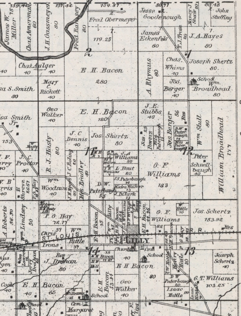
Presumably Lost Forty Cemetery is located in, or at least very close to, the Lost Forty. If so, the Lost Forty must have been in Section 12 of Mackinaw Township, and perhaps Hollands Creek flowed through it, the tributary creek being confused with the actual river.
On the other hand, the county atlas maps of 1864, 1873 and 1891 do not indicate any unknown or disputed ownership of land in Section 12.
To help solve the mystery, one of our readers, Vivien White of Tremont contacted us in the summer of 2013 and shared some of her childhood memories. White, then 88 years old, said that when she was a child, she lived on a farm in or near Section 12 of Mackinaw Township. Her father, Charles White, rented the farm from an owner whom Vivien believed was from the Washington or Eureka area – but she did not recall the owner’s name or the exact location of the farm, and she didn’t remember exactly where the farm was.
What she remembered, though, is that the farm bordered on the Lost Forty, and that she used to play in that area as a child. White agrees that Allensworth’s old description of the tract – “a continuous series of abrupt and deep ravines . . . The ridges are full of fox dens . . . dense forest” – is accurate. (White remembers a time when she crawled into one of the fox dens. When her father found out, he scolded her because she could have been attacked or bitten by a fox.) However, she said that, contrary to Allensworth, the Mackinaw River did not “wind its way through the tract,” but touched on it or came near it.
So, although we don’t know precisely where the Lost Forty was, White’s recollections at least appear to confirm our initial investigations.


