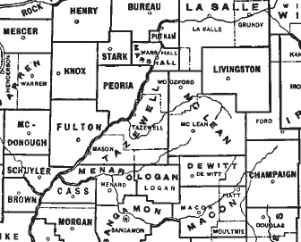
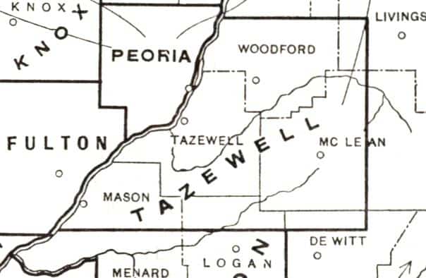
After our recalling the story of the creation of Tazewell County last week, this week we will follow up with an account of how Tazewell County’s borders were changed through the creation of new counties, reducing Tazewell to its present size. It is worth remembering that the early history of Tazewell County overlaps not only with the wider history of Illinois, but also the local histories of McLean, Mason, Woodford, Livingston, Logan, and DeWitt counties, for parts of those counties originally were in Tazewell county. Indeed, over half of McLean County and all of Woodford County were in Tazewell County.
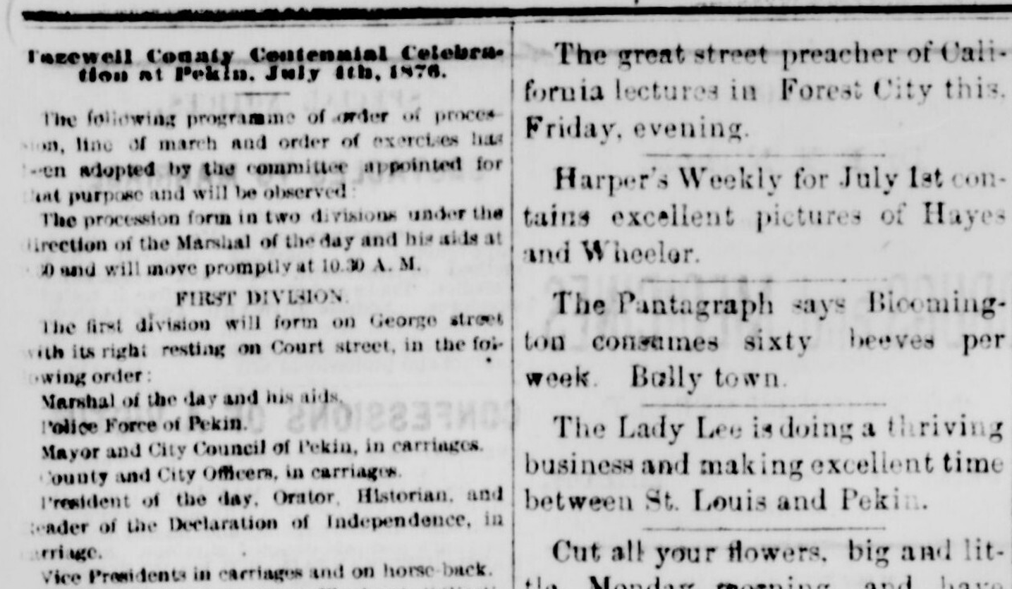
In the “From the Local History Room” column that ran 9 March 2013, we recalled the story of the old rivalry between Pekin and Tremont as the two communities contended for the honor and status of being the governmental seat of Tazewell County. It was due largely to that struggle that Tazewell County acquired its present geographical boundaries. As we noted last week, the county originally was much larger than it is today.
The trimming and shaving of Tazewell County during the 1830s and 1840s was just the last part of the process by which the county acquired its permanent shape on the map. When the Illinois General Assembly first created Tazewell County in 1827, the county was much larger than it is today. The frequent change in the county’s borders up to the year 1839 (prior to the Tremont-Pekin struggle) can be tracked by consulting the maps of Illinois found in one of the volumes in the Pekin Public Library’s Local History Room: a 63-page booklet published by the State of Illinois in 1991 with the title, “Origin and Evolution of Illinois Counties.”
This booklet presents the development of the counties of Illinois beginning in 1790, when the land that would become the State of Illinois was a part of the Northwest Territory. In that year, there were only two counties in Illinois: Knox County (not to be confused with today’s Knox County which borders Peoria County on the west), organized 27 April 1790, which included most of the eastern half of Illinois and parts of Indiana, and St. Clair County, organized 20 June 1790, which took up about the southwestern third of Illinois. The Illinois River served as the northwestern boundary of St. Clair County and part of the northwestern and western border of Knox County. Most of present Tazewell County was then a part of Knox County, with about a fourth of Tazewell including in St. Clair County.
By 1801, Illinois was a part of the Indiana Territory, and the county lines of St. Clair and Knox counties were moved and enlarged on 9 Feb. 1801, with almost all of Illinois (including the future Tazewell County) encompassed by St. Clair County — and St. Clair’s territory extended north to the Canadian border. The southern quarter of Illinois was assigned to Randolph County, which had been created 5 Oct. 1795. Knox County, however, was almost edged out of Illinois altogether. Most of Knox County was in Indiana, and just a narrow strip along the eastern border of what would become the State of Illinois was all that remained of Knox in Illinois. The boundaries of St. Clair and Randolph counties were adjusted further on 25 March 1803.
Six years later, in 1809, old Knox County was no more – by a 28 April 1809 proclamation by Nathaniel Pope, acting territorial governor of the new Territory of Illinois, Illinois’ counties were reduced to two, Randolph in the south and St. Clair in the north. In only three years, however, the territorial counties had been re-envisioned, with the southern quarter of Illinois divided on 12 Sept. 1812 among St. Clair, Randolph, Gallatin and Johnson counties, and the northern three-quarters of the territory (including Tazewell) assigned to Madison County.
Apart from some border adjustments of the southernmost counties, that basic arrangement remained until 1815, when two new counties were created: Edwards County, which was formed on 20 Nov. 1814 out of the eastern half of Madison County and part of Gallatin County by drawing of straight north-south line right through the middle of the Illinois Territory, and White County in southern Illinois, created on 9 Dec. 1815 out of part of Gallatin County. The remaining territory of Madison County included the area that would later become Tazewell County.
By 1817 – just a year before Illinois became a state – the northern three-fourths of the Illinois Territory were taken up by three large counties: Crawford County in the east (which was most of the former Edwards County, created on 31 Dec. 1816), Madison County in the west (which was most of the former Madison County), and a new county named Bond, created on 4 Jan. 1817 by slicing a perfect north-south strip from Madison County. Most of Tazewell County was included in Bond County, while the western part of Tazewell was in Madison County. The western border of Bond County passed right through the future site of Pekin.
Four years later, in 1821, the fledgling State of Illinois redrew the county borders in the northern three-fourths of its territory, reducing Bond County to a tiny rump of its former area and creating several new counties. One of them, Sangamon County, created on 30 Jan. 1821, extended from Sangamon County’s present southern border as far north as the northern border of Putnam County at the Illinois River. Within Sangamon’s boundaries was the future Tazewell County – and in the summer of 1824, along the northwestern border of Sangamon County at the Illinois River, Jonathan Tharp built his log cabin where the city of Pekin would later arise.
On 13 Jan. 1825, Sangamon County was reduced in size, with its northern half being separated from Sangamon and administered from a new county named Peoria County for the Peoria tribe of the Illiniwek confederacy. The former northern half of Sangamon east of the Illinois River (which included the present Tazewell County) was an unorganized territory that was not formally a part of Peoria County, but it also was not a county in its own right and was administered by Peoria County.
Finally, on 31 Jan. 1827, the State of Illinois created Tazewell County out of lands that not only included the whole of the present Tazewell County, but also encompassed territory from the former Fayette County (which territory is today the western half of McLean County) as well as the whole of the future Woodford County and parts of Mason, Logan and De Witt counties.
Tazewell’s first reduction in size came with the creation of McLean County on 25 Dec. 1830. At that time, Tazewell acquired most of its current eastern border. Tazewell’s territory then still included a good part of what would become Woodford and Mason counties as well as a northern slice of the future Logan County.
Tazewell County would retain that shape and size for much of the following 10 years, after which the Pekin-Tremont rivalry reduced Tazewell to its permanent boundaries by 1841, with the creation of Mason County out of Tazewell and Menard counties on 20 Jan. 184, and the creation of Woodford County out of Tazewell County and McLean County on 27 Feb. 1841.