With our country now celebrating its Semiquincentennial (250 years), this is an opportune for us to look back to the founding of Tazewell County, which will celebrate its bicentennial in 2027.
After Illinois achieved statehood, new settlers poured into central Illinois throughout the 1820s, making new homes for themselves in and around Fort Clark (Peoria) or clearing land for farms along the eastern shores and bluffs of Peoria Lake and the Mackinaw River basin. Those were the years that saw the arrival of Tazewell County pioneers William Blanchard, Nathan Dillon, and William Holland. Another of those early settlers was an Ohio resident named Jonathan Tharp (1794-1844), who built a log cabin on a ridge above the Illinois River in 1824 at a spot that is today the foot of Broadway in Pekin. Tharp’s cabin was the seed that would soon sprout and grow into the city of Pekin.
The result of the wave of immigration of those years was that in 1825, a mere seven years after statehood, the State Legislature erected a new county, named for the Peoria tribe of the Illiniwek who had once dwelt in that place.
Tazewell County came along almost on the heels of Peoria County’s founding. As we have often recalled in this column, Tazewell County was established in 1827. It was Illinois’ 38th county – the 23rd county since statehood. Prior to its creation, Tazewell County had passed from the jurisdiction of Sangamon County to become a part of Peoria County for less than two years.

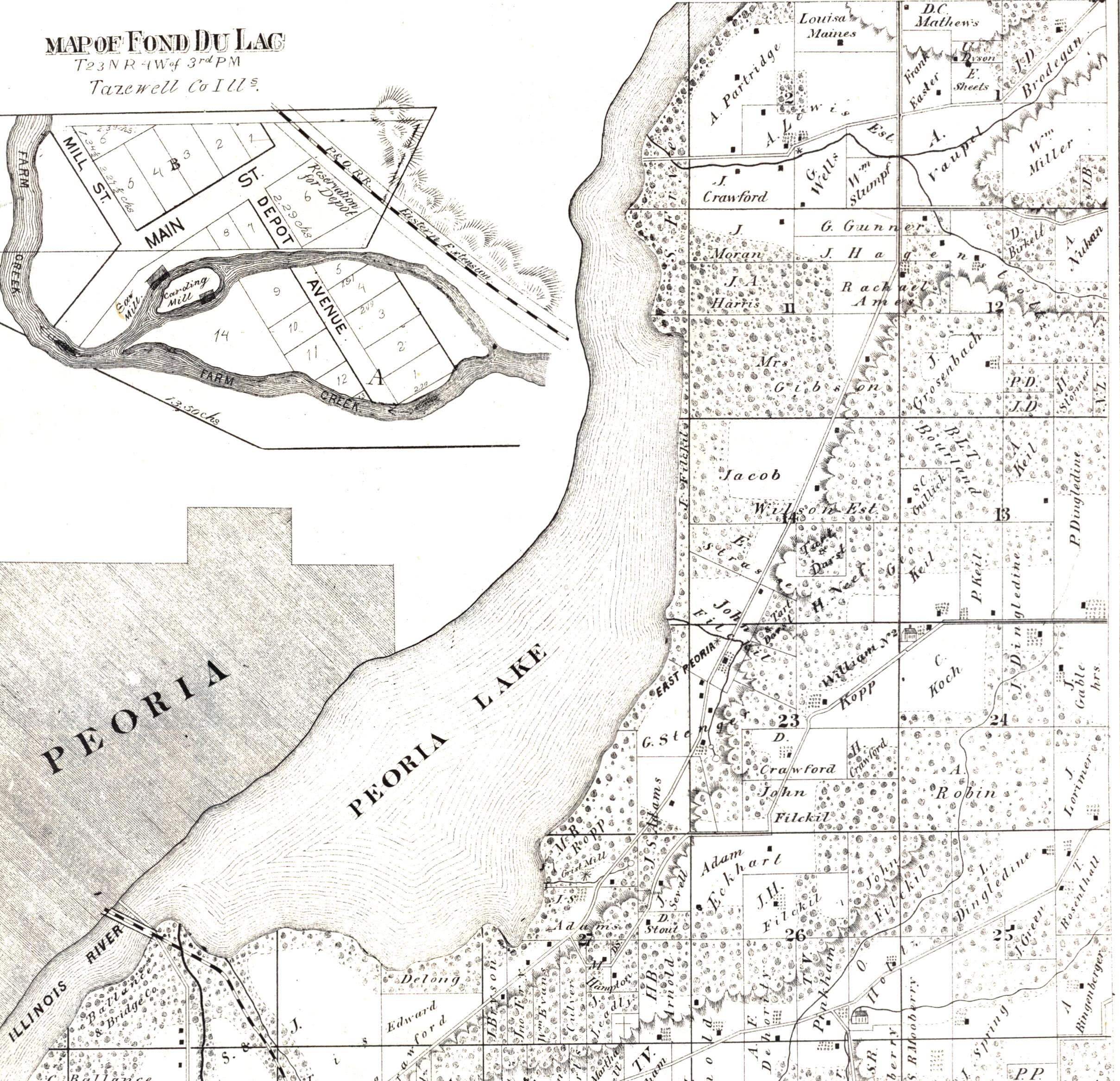
The original plan was to name the new county “Mackinaw,” after the Michilimackinaw or Mackinaw River, the tributary of the Illinois River that flowed through it (a Kickapoo chief named Machina or Mackinaw also lived with his people in Tazewell County in those years). However, one of the county’s prominent pioneers, Gideon Henkel Rupert (1799-1877), a Virginia native who soon became a successful businessman, landowner, and the wealthiest man in Pekin, intervened to ask to have the proposed bill to establish the county amended, so the new county would instead be named for U.S. Senator Littleton W. Tazewell of Virginia. The first county seat was still named Mackinaw, though.
Here is the account of the founding of Tazewell County from “Mackinaw Remembers: 1827-1977,” page 2, the commemorative volume that was published for Mackinaw’s Sesquicentennial (emphasis added):
“On December 29, 1826, Henry J. Ross gave the Fifth General Assembly his intention of introducing a bill forming a new county out of part of Peoria County. January 13, 1827, Robert McLaughlin of Fayette reported a bill forming a new county out of counties Peoria and Fayette. It was ordered for a second reading and on January 15, 1827, went to the committee of the ‘whole.’ The next day Jonathan Pugh made it known those living near the Illinois in Fayette request to be attached to Peoria. It was then that David Blackwell of St. Clair made a motion the bill be amended to read: ‘An Act Creating Mackinaw County’ — and by that title it passed the House. The Senate amended it, reading it ‘An Act Creating Tazewell County.’ It was so approved January 31, 1827.
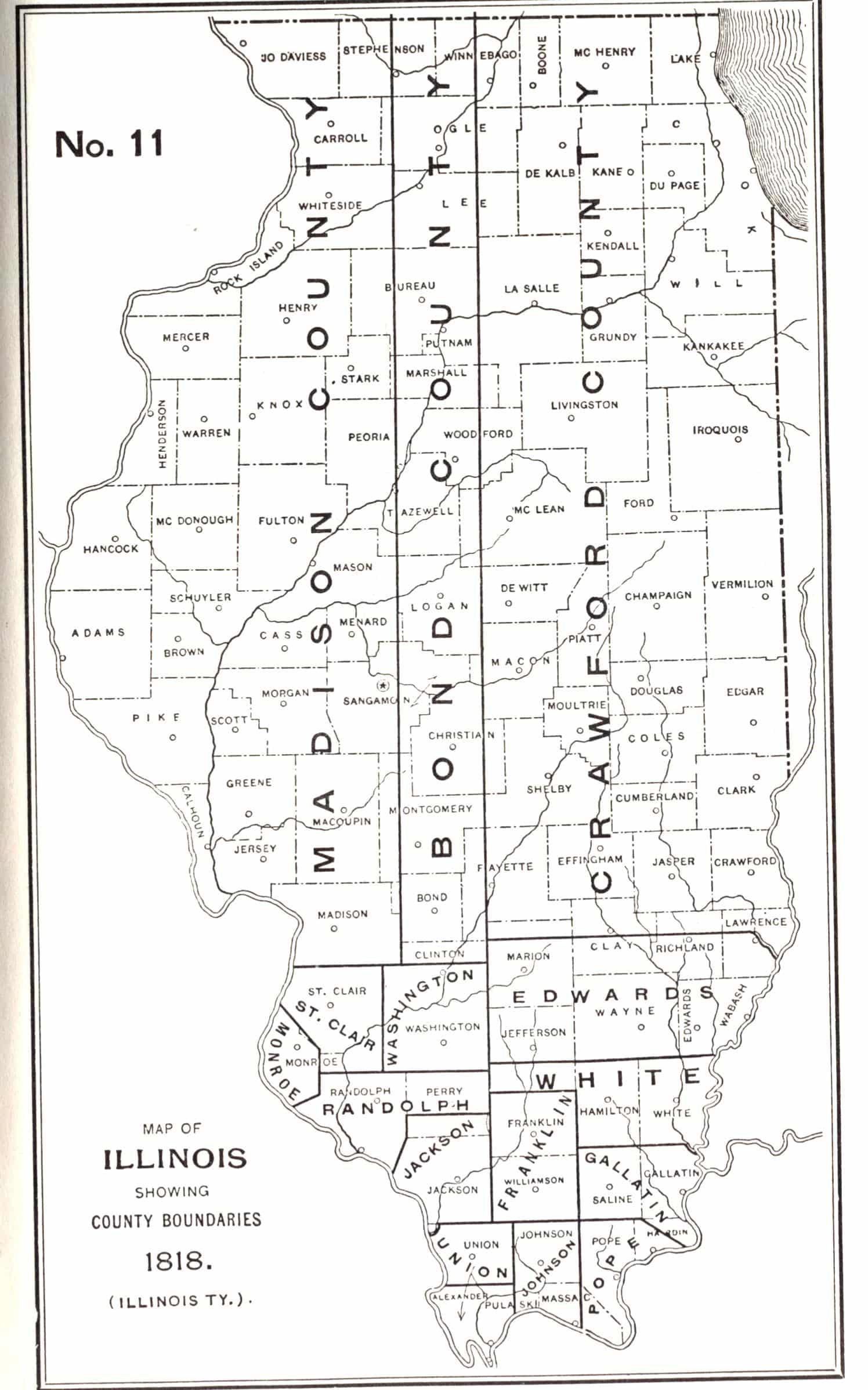
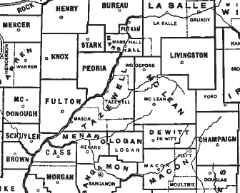
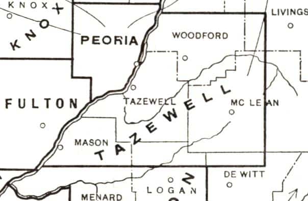
“There remains on file in the office of the Secretary of State a bill endorsed ‘Act Creating the County of Tazewell.’ The bill itself originally read ‘Act forming a new county out of the counties of Fayette and Peoria.’ but, erasures having been made, now reads ‘Act Creating Mackinaw County.’ The enrolled bull has not been examined, which was among the errors forming new counties. After it was passed as the County of Tazewell, this gave it the boundaries that included all of its present territory, plus parts of the modern Logan, Mason, McLean, Livingston and DeWitt, and attached parts of Putnam, Marshall, LaSalle, and Livingston. Mackinaw was named the county seat. Tracts of land became parts of new counties. The present day boundaries were fixed in 1841.”
The full text of the “AN ACT creating the County of Tazewell” can be consulted in “The revised code of laws of Illinois : enacted by the fifth General Assembly, at their session held at Vandalia, commencing on the fourth day of December, 1826, and ending the nineteenth of February, 1827 : published in pursuance of law,” which is available online here.
Now, in its explanation of where Tazewell County got its name, the earliest history of Tazewell County, published by Charles C. Chapman in 1879, promulgated an unfortunate error that came to be repeated in subsequent works of our local history. On page 209, Chapman’s history says, “The county was named in honor of Hon. John Tazewell, United States Senator from the State of Virginia. There is a county in that State which also bears the same name, these being the only two in the United States.”
That sounds straightforward enough, although it doesn’t explain why a new Illinois county would be named after a Virginia senator. But the most serious problem with Chapman’s statement is that there was no Virginia senator named “John” Tazewell.
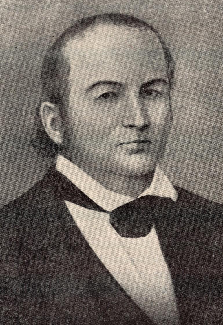
There were, in fact, two Virginia senators surnamed “Tazewell,” who were father and son – Henry Tazewell (1753-1799), who served in the U.S. Senate from 1794 until his death, and Henry’s son Littleton Waller Tazewell (1774-1860), who served in the U.S. Senate from 1824 to 1832. Since Tazewell County was formed while Littleton W. Tazewell was a senator, no doubt he was who Chapman had in mind when he said the county was named for a U.S. senator from Virginia. (However, Tazewell County in Virginia was named after Henry Tazewell, the father, as were the Town of Tazewell in Virginia and the Town of Tazewell in Tennessee.)

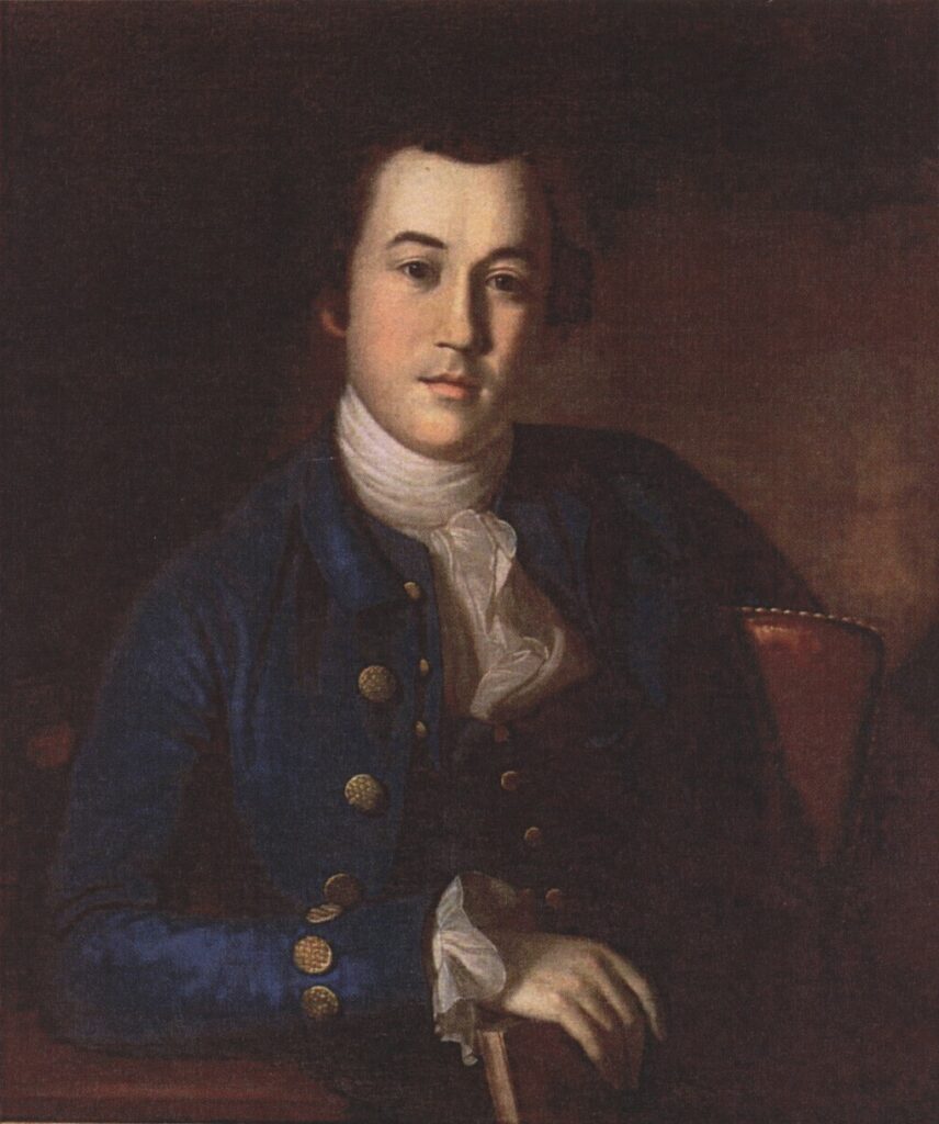
Gladys M. Dubson’s 1939 Illinois State University master’s thesis, “Historical and Economic Survey of Tazewell County, Illinois, 1663-1939,” which is part of the Pekin Public Library’s Local History Room collection, says (page 2) that it was Littleton Waller Tazewell “for whom Tazewell County, Illinois, was named.” Dubson includes several paragraphs of biography and genealogy of Littleton W. Tazewell. In addition, John Drury’s 1954 “This is Tazewell County, Illinois,” pages 3-4, says, “The new county on the Illinois River was named after Littleton Waller Tazewell, a leading American lawyer and political leader of the time. When the county was organized in 1827, Tazewell was serving in the United States senate, being chairman of that body’s committee on foreign relations. In later years, Tazewell was elected governor of Virginia. During most of his public career he had been a strong opponent of President Jackson’s policies. He died in 1860.”
The Pekin Public Library’s most detailed resource on the life of U.S. Sen. Littleton W. Tazewell is Norma Lois Peterson’s 311-page biography of Tazewell County’s namesake Littleton Waller Tazewell, published in 1983, a copy of which was graciously donated by the Tazewell County Genealogical & Historical Society to the library’s Local History Room collection.
Following is the account of the founding of Tazewell County as found in Charles C. Chapman’s 1879 “History of Tazewell County,” pages 207-209 (emphasis added):
“Tazewell county was organized by an act of the Legislature January 31st, 1827, with the following boundaries: Beginning at the northeast corner of township twenty, north of the base line, and range three east of the third principal meridian, thence north on said line to the north line of township twenty-eight north, thence west to the middle of the Illinois river, thence down said river to the north line of township twenty north, thence east to the place of beginning.
“In the act organizing the county January 31, 1827, an error occurred in describing the boundaries. This error was corrected by an act re-establishing the boundaries, passed January 22, 1829.
“The territory comprising the county of Tazewell formed part of the counties at the dates named in the several subdivisions of the State prior to the organization of the county, as follows:
“1809 — At this date Illinois Territory was organized, and was subdivided into the counties of Randolph and St. Clair. Tazewell was included in the county of St. Clair.
“1812 — Tazewell formed part of the county of Madison.
“1814 — Tazewell was included in the counties of Madison and Edwards: west of the third principal meridian in Madison, east of the meridian in Edwards.
“1816 — Tazewell was included within the boundaries of Madison and Crawford counties: east of the meridian in Crawford, west in Madison.
“1817 — Tazewell formed part of the counties of Bond and Crawford: west of the meridian in Bond, east in Crawford.
“1819 — Tazewell was included in Clark and Bond counties: west of the meridian in Bond, east in Clark.
“1821 — Tazewell formed part of Fayette and Sangamon counties: west of the meridian in Sangamon, east in Fayette.
“1827 — Tazewell organized January 31st: boundary defective.
“1829 — Tazewell boundaries defined, and error in law of 1827 corrected as above given. County originally created from territory then comprising part of the counties of Sangamon and Fayette: west of the third principal meridian taken from Sangamon, east of the meridian, comprising 24 townships, taken from Fayette.
“1830 — McLean county was formed by taking off the three ranges east of the meridian and range one west of the meridian.
“1839 — Logan county was created, taking off three townships on the south.
“1841 — The counties of Mason and Woodford were organized, and Tazewell reduced to its present boundaries.
“The commissioners to locate the county seat were Thos. M. Neale, Wm. L. D. Ewing and Job Fletcher. They were by the act of organization required to meet on the third Monday of March, 1827, or within five days thereafter, at the house of Wm. Orendorff, for the purpose of locating the county seat, which, when located, was to be called ‘Mackinaw.’ Until county buildings were erected the courts were required to be held at the house of Wm. Orendorff. Election for county officers at the house of said Wm. Orendorff on the second Monday of April, 1827.
“All that part of Fayette lying east and north of Tazewell was attached to Tazewell for county purposes.
“In the year 1825 the Legislature created Peoria county, and attached to it for all county purposes all of the territory north of town 20 and west of the third principal meridian, thus including all the present county of Tazewell. Nathan Dillon, William Holland and Joseph Smith were chosen County Commissioners for the new county. The former two resided in this county. They held their first meeting at Peoria March 8, 1825.
“When the population of Tazewell was thought to be sufficiently large to regularly organize, an election was held in April, 1827, and Benjamin Briggs, George Hittle, and James Lotta were chosen County Commissioners. The Commissioners at once proceeded to hold a meeting and consummate the organization. This they did at the house of William Orendorff, April 10, 1827. . . .
“The county at this time was very large; even in 1829, when a new boundary was formed, it contained 79 townships. It has been divided for the formation of other counties so often that it has finally been reduced to 19 townships.
“The county was named in honor of Hon. John Tazewell (sic – Littleton), United States Senator from the State of Virginia. There is a county in that State which also bears the same name, these being the only two in the United States.”